
Big data analytics transforms hazard mapping by integrating real-time data from sensors, satellites, and social media, allowing you to monitor hazards as they develop. It uses predictive models to assess risks and forecast potential impacts, enabling you to act proactively. Dynamic maps reflect current situations, helping you make faster, more informed decisions during crises. If you continue exploring, you’ll discover how these innovations advance disaster prevention and response strategies even further.
Key Takeaways
- Big Data analytics integrate diverse real-time data sources like sensors, satellites, and social media to monitor hazards continuously.
- Advanced algorithms analyze historical and current data to predict disaster likelihood and potential impact more accurately.
- Data-driven hazard mapping enables dynamic updates, improving situational awareness during emergencies.
- Big Data models support proactive risk assessment, targeted warnings, and efficient resource deployment.
- The evolving use of Big Data transforms hazard mapping into a predictive, adaptive system for enhanced disaster preparedness.

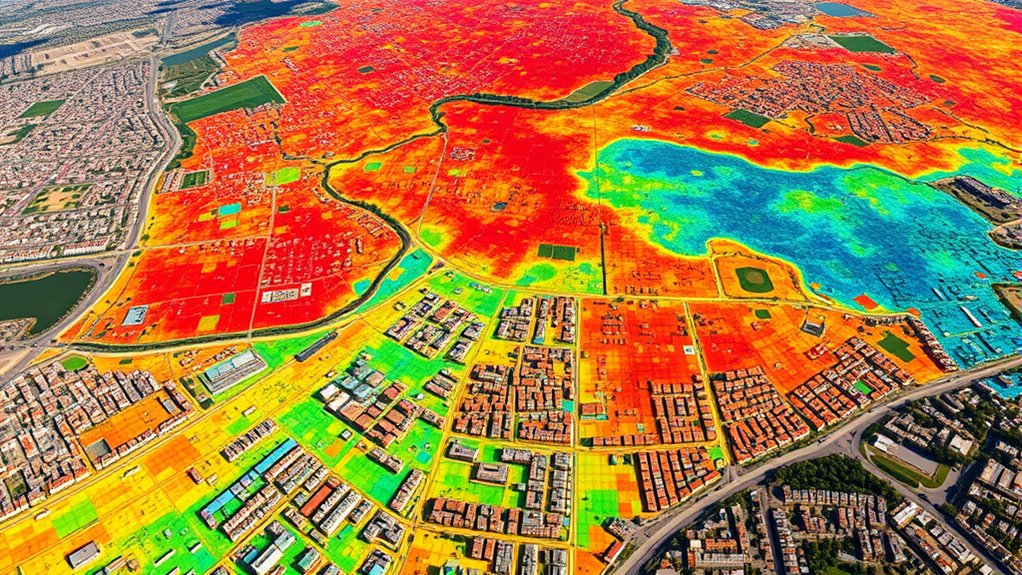
Have you ever wondered how big data analytics is transforming hazard mapping? The answer lies in the power of real-time monitoring and predictive modeling, which are revolutionizing how we understand and respond to natural and man-made hazards. Traditional hazard mapping relied heavily on historical data and manual analysis, often causing delays in identifying emerging threats. Now, with big data, you can access a continuous stream of live information from sensors, satellites, social media, and other sources, enabling you to monitor hazards as they unfold. This real-time monitoring provides immediate insights, allowing you to detect early signs of disasters like floods, earthquakes, or wildfires, giving you a critical advantage in planning and response.
Predictive modeling takes these insights a step further. By analyzing vast amounts of historical data alongside real-time inputs, you can develop models that forecast the likelihood and potential impact of hazards. These models sift through complex variables—such as weather patterns, geological conditions, and human activity—to project future events with increasing accuracy. This proactive approach shifts your focus from merely reacting to disasters to preventing or mitigating their effects before they happen. For instance, predictive models can identify areas at heightened risk of flooding based on rainfall forecasts and topographical data, allowing authorities to issue timely warnings or evacuations.
With big data analytics, hazard mapping becomes more dynamic and adaptive. The integration of real-time monitoring feeds into predictive models creates a feedback loop: as new data arrives, models update their predictions, refining your understanding of evolving risks. This continuous learning process enhances your ability to make data-driven decisions swiftly, whether it’s deploying emergency services, adjusting infrastructure, or informing the public. Moreover, the granularity of big data enables you to create detailed hazard maps at local levels, pinpointing vulnerable communities and infrastructure. This precision ensures resources are allocated efficiently and response efforts are targeted accurately.
In essence, big data analytics transforms hazard mapping from a static, historical exercise into a living, breathing system. You’re no longer limited to past events; you can anticipate future hazards with greater confidence. Real-time monitoring keeps you informed as situations develop, while predictive modeling empowers you to plan effectively and act decisively. As technology advances, this synergy between data streams and predictive insights will become even more sophisticated, making hazard mapping an essential tool for safeguarding communities and minimizing disaster impacts. Incorporating somatic therapy techniques into emergency response strategies is emerging as a complementary approach to support responders’ resilience and well-being during crises. In this new era, your ability to harness big data determines how well you can predict, prepare for, and respond to hazards before they escalate into crises.

3 Packs Explosive-Gas-Detectors & Carbon-Monoxide-Detectors Plug in,4-in-1 Upgraded Sensors,Real-time Monitor & Digital Display,Natural Gas Leak Detector & CO Alarm for Home,RV,Apartment
4-in-1 upgraded high-sensitivity sensor
As an affiliate, we earn on qualifying purchases.
As an affiliate, we earn on qualifying purchases.
Frequently Asked Questions
How Does Big Data Improve Early Hazard Detection Accuracy?
Big data improves early hazard detection accuracy by enabling real-time monitoring and predictive modeling. You can analyze vast amounts of sensor data, social media feeds, and environmental reports instantly, identifying warning signs faster. Predictive modeling helps forecast potential hazards before they occur, giving you essential lead time. This combination allows you to respond more effectively, minimizing risks and enhancing safety measures for communities and infrastructure.
What Are the Main Challenges in Integrating Diverse Data Sources?
Imagine trying to piece together a puzzle with mismatched pieces—that’s what integrating diverse data sources feels like. The main challenges you face are data heterogeneity, which means dealing with different formats and sources, and data standardization, ensuring all data aligns for analysis. You need to develop strategies to harmonize these varied inputs so they can work together seamlessly, enabling accurate hazard mapping and better decision-making.
How Can Small Organizations Access Big Data Analytics Tools?
You can access big data analytics tools by leveraging data democratization efforts and affordable cloud-based platforms, reducing cost barriers. Many providers offer scalable solutions with user-friendly interfaces, enabling small organizations to analyze large datasets without significant investments. Additionally, open-source tools and online training resources empower you to develop your skills and make data-driven decisions effectively, leveling the playing field regardless of your organization’s size or budget.
What Are Privacy Concerns Related to Hazard Mapping Data?
Imagine your hazard mapping data as a delicate web of interconnected threads, vulnerable to being pulled apart. Privacy concerns arise around data security, risking sensitive information falling into the wrong hands. Ethical considerations also come into play, ensuring you respect individuals’ rights and avoid misuse. You must stay vigilant, safeguarding this essential data to protect privacy while harnessing its power for accurate hazard assessment.
How Is Machine Learning Used in Hazard Prediction Models?
You use machine learning to enhance hazard prediction models by analyzing vast datasets for patterns and trends. It automatically identifies risk factors and predicts potential hazards with increased accuracy. Machine learning algorithms process environmental data, historical incidents, and sensor inputs to generate real-time risk assessments. This proactive approach helps you anticipate hazards more effectively, enabling better planning, response, and mitigation strategies to protect communities and infrastructure from future threats.

Atlas of Remote Sensing of the Wenchuan Earthquake
As an affiliate, we earn on qualifying purchases.
As an affiliate, we earn on qualifying purchases.
Conclusion
By leveraging big data analytics, you can enhance hazard mapping accuracy and responsiveness. Some might worry about data privacy or complexity, but the benefits far outweigh these concerns. With proper safeguards, you guarantee sensitive information stays protected while gaining real-time insights. Embracing big data not only improves disaster preparedness but also helps you make smarter, faster decisions. Don’t let fear hold you back—adopting advanced analytics is essential for effective hazard management today.

SecuLife New 2026 Fall Alert Device, Medical Alert Pendant with for Seniors, SOS Call, GPS Tracking & Reminders – Wearable Emergency Necklace for Elderly, Waterproof, 2-Way Calling, Panic Button
❤️ 𝐌𝐞𝐝𝐢𝐜𝐚𝐥 𝐀𝐥𝐞𝐫𝐭 𝐏𝐞𝐧𝐝𝐚𝐧𝐭 𝐰𝐢𝐭𝐡 𝐅𝐚𝐥𝐥 𝐃𝐞𝐭𝐞𝐜𝐭𝐢𝐨𝐧: Designed for seniors and individuals with medical conditions, this wearable alert…
As an affiliate, we earn on qualifying purchases.
As an affiliate, we earn on qualifying purchases.

Design Any Disaster: The Revolutionary Blueprint to Master Your Next Crisis or Emergency
As an affiliate, we earn on qualifying purchases.
As an affiliate, we earn on qualifying purchases.