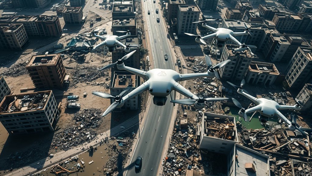

Utilizing drones in damage assessment and relief efforts lets you quickly survey affected areas without risking human lives. They deliver detailed, real-time images and data, making it easier to identify hazards and prioritize rescue operations. Equipped with various payloads like thermal sensors and high-resolution cameras, drones efficiently cover inaccessible zones, speeding up decision-making. With advancements in technology and strategic planning, you can maximize their impact in emergencies—exploring more will reveal how to optimize drone deployment further.
Key Takeaways
- Drones enable rapid, detailed damage assessments in hazardous or inaccessible areas, supporting timely relief decisions.
- Equipped with high-resolution cameras and thermal sensors, drones identify trapped individuals and assess structural integrity.
- Autonomous flight paths ensure comprehensive coverage, speeding up damage analysis and resource allocation.
- Real-time data transmission enhances emergency response efficiency and coordinates relief efforts effectively.
- Advanced AI analysis of drone imagery accelerates damage detection, prioritizing critical areas for immediate aid.

MSMV High-Resolution 4K HD Camera Drone, Wireless RC Toys for Boys Girls, One Button Return, Emergency Stop, Headless Mode, 360° Flips, 2 Batteries & Carrying Case for Kids Adults Beginners, Black
This MSMV drone with camera is fitted with high-resolution 4K HD camera. As practical 4K drones with camera…
As an affiliate, we earn on qualifying purchases.
As an affiliate, we earn on qualifying purchases.
The Role of Drones in Rapid Damage Evaluation

Drones have revolutionized how emergency teams evaluate damage after a disaster. With autonomous navigation, they can quickly navigate through hazardous areas without risking human lives, providing rapid, detailed assessments. You can customize their payloads to suit specific needs, such as high-resolution cameras, thermal sensors, or LiDAR systems, allowing for exhaustive damage analysis. This adaptability makes drones invaluable tools for gathering precise data in complex environments, speeding up decision-making. Autonomous flight paths ensure thorough coverage, even in inaccessible or dangerous zones, delivering real-time imagery and data. Payload customization makes drones versatile tools that enhance your ability to evaluate damage swiftly and accurately, ultimately improving response efficiency and saving lives during critical moments.

Autel Robotics EVO Lite 640T Enterprise Bundle, 640×512 T~hermal&1/2'' CMOS 48MP V~isible C-a-mera, 1-16x Digital Zoom, AI Target Recognition, 12KM Transmission, 866g Lightweight, 40Min Max Time
👍【2026 NEW: AUTEL EVO LITE 640T ENTERPRISE】Weighing just 866g and featuring a compact foldable design (210×123×95mm), the Autel…
As an affiliate, we earn on qualifying purchases.
As an affiliate, we earn on qualifying purchases.
Types of Drone Technologies Used in Disaster Zones

In disaster zones, a variety of drone technologies are deployed to gather critical information quickly and safely. Fixed-wing drones excel at aerial mapping, covering large areas swiftly to create detailed maps of affected regions. Multirotor drones offer agility and stability, ideal for close-up inspections of damaged infrastructure. Some drones are equipped with payload delivery systems, enabling them to transport essential supplies like medical kits or water to inaccessible areas. Thermal imaging cameras help identify heat signatures, locating trapped or injured individuals. High-resolution cameras provide real-time visuals for assessment teams. These diverse drone technologies work together to deliver accurate data, enhance situational awareness, and support effective disaster response efforts. Additionally, integrating emotional support strategies for affected populations can improve community resilience during recovery phases. Understanding drone capabilities, such as long endurance flight, can further optimize their deployment in disaster scenarios.

Universal Drone Payload Delivery System with Remote Release – Airdrop Mechanism & Multi-Purpose Clip for Wedding Rings, Fishing Bait, Fits DJI Mini 3 Pro/Mavic 3 Pro/Mini 4 Pro/Air 3/Avata & More (Gray)
【Broad compatibility】Universally Drone Airdrop System, for DJI Mini4/Mini3/Mini2/Air2/Air2S/Mavic 3/Mavic 2 DJI Series Drone/Spark.(Note: but not suitable for DJI…
As an affiliate, we earn on qualifying purchases.
As an affiliate, we earn on qualifying purchases.
Advantages of Drone Surveillance in Emergency Situations

The rapid deployment of drone surveillance offers significant advantages during emergencies by providing real-time, high-quality data that enhances decision-making. With drones, you gain quick access to affected areas, enabling faster assessments and more targeted relief efforts. This immediacy helps save lives and reduces property damage. Additionally, implementing data-driven strategies can optimize resource allocation and improve overall response efficiency. Drones are particularly effective in disaster zones, where traditional methods may be limited or unsafe. However, privacy concerns can arise as drones capture detailed imagery of individuals and private property. You must balance the benefits with responsible data handling. Furthermore, drones can be cost-effective compared to traditional methods like helicopters or ground inspections, lowering overall response expenses. Their ability to operate in hard-to-reach or hazardous zones further amplifies their value. Incorporating professional voice actors in public awareness campaigns can help educate communities about the responsible use of drone technology. Moreover, understanding public perception of drone use is crucial for fostering community support and trust. Recognizing the importance of cost-effectiveness in emergency responses can lead to more sustainable and scalable deployment strategies. Overall, drone surveillance streamlines emergency response, but you should address privacy issues and consider the cost implications to maximize its benefits effectively.

LEFEET Autonomous Underwater Vehicle for Seabed Inspections, High-Precision Marine Survey Drone with Sonar & Camera, Waterproof
Advanced Seabed Mapping: Equipped with high-resolution sonar and camera systems, the LEFEET AUV captures detailed underwater terrain and…
As an affiliate, we earn on qualifying purchases.
As an affiliate, we earn on qualifying purchases.
Case Studies Demonstrating Drone Effectiveness

Real-world examples showcase how drone technology has transformed emergency response efforts. In disaster zones, drones quickly assess damage, providing real-time visuals that guide rescue teams. For instance, after hurricanes, drone flights helped identify inaccessible areas, saving lives. These successes depend on proper drone maintenance, ensuring reliable operation during critical moments. Public perception also plays a crucial role; communities increasingly view drones as valuable tools, boosting support for their deployment. In one case, a drone company partnered with local authorities to monitor wildfire spread, demonstrating efficiency and safety. Such case studies highlight drones’ effectiveness in rapid damage assessment and relief coordination, emphasizing that ongoing maintenance and positive public perception are essential for widespread adoption. Additionally, understanding asset division laws and procedures can help agencies plan more effective disaster response strategies. These examples prove that, when managed well, drones considerably enhance emergency responses. Moreover, integrating dynamic communication exercises into team training can improve coordination during drone operations, leading to more accurate assessments. Proper training protocols ensure teams operate drones efficiently in high-pressure situations, maximizing their impact during crises. Furthermore, establishing standard operating procedures for drone deployment can streamline responses and improve overall effectiveness.
Challenges and Limitations of Drone Deployments

What are the main hurdles that can limit the effectiveness of drone deployments in disaster response? Privacy concerns often arise, as drones collect detailed images that may invade individuals’ or communities’ privacy. Regulators also impose restrictions, slowing deployment times. Logistical challenges can hinder drone use, especially in inaccessible areas where deploying and operating drones requires careful planning and coordination. Weather conditions, such as storms or high winds, can ground drones or reduce their effectiveness. Limited battery life and payload capacity restrict the amount of data collected and the duration of flights. Additionally, technical issues like signal interference or malfunctions can compromise operations. Addressing these challenges requires careful planning, adherence to regulations, and technological advancements to maximize drone benefits in disaster scenarios.
Integration of Drones With Other Disaster Response Tools

Integrating drones with other disaster response tools enhances coordination and efficiency during emergencies. By combining autonomous navigation capabilities, drones can navigate complex environments without human intervention, ensuring faster deployment. When paired with aerial mapping technology, they provide real-time, detailed visuals of affected areas, supporting decision-making. These integrations allow rescue teams to overlay drone data with GIS systems, improving situational awareness. Drones can work alongside ground vehicles, satellites, and communication networks to create a thorough response strategy. This synergy accelerates damage assessment, resource allocation, and relief efforts. Additionally, utilizing organic and natural juices can help maintain the health and hydration of rescue personnel during prolonged operations. Employing holistic health approaches further supports responder well-being and operational longevity. Integrating AI security technologies, such as real-time monitoring and anomaly detection, can enhance the safety and effectiveness of drone operations during disaster response. The use of interoperable systems ensures that all tools communicate seamlessly, reducing delays and errors. Incorporating training programs for personnel on advanced drone operations can also improve overall response efficiency. Ultimately, seamless integration of drones with existing tools streamlines operations, reduces response times, and enhances the accuracy of assessments, making disaster management more effective and coordinated.
Regulatory Considerations for Drone Operations in Emergencies

Regulatory considerations play a critical role in ensuring safe and effective drone operations during emergencies. You must navigate airspace restrictions to prevent interference with manned aircraft and comply with privacy concerns that protect individuals’ rights. Emergency situations often require quick decision-making, but regulations may limit drone flight zones or require special waivers. Understanding these rules helps avoid legal issues and safety hazards. Additionally, referencing support hours for various services can assist responders in coordinating efforts efficiently during critical times. Proper planning and adherence to regulatory compliance are essential to mitigate risks associated with drone operations in such scenarios. Awareness of security zone info can further aid in maintaining safe operational boundaries and avoiding restricted areas during emergency responses. Being aware of airspace restrictions is crucial for maintaining compliance and ensuring the safety of all involved. Maintaining awareness of airspace regulations can further streamline operations and reduce delays during urgent missions.
Future Innovations Enhancing Drone Capabilities

Future innovations like AI-driven image analysis will enable your drones to identify damage more quickly and accurately. Extended flight durations will allow them to cover larger areas without frequent recharging. These advancements will make disaster response faster and more efficient, saving lives and resources. Additionally, integrating ethical considerations into drone deployment will ensure responsible and equitable use during relief efforts.
AI-Driven Image Analysis
How can AI-driven image analysis revolutionize drone-based damage assessments? By enabling real-time, precise evaluations, AI enhances drone effectiveness. With autonomous navigation, drones can efficiently survey disaster zones without manual control, covering large areas quickly. AI algorithms analyze images instantly, using image segmentation to identify damaged structures, blocked roads, or hazardous zones. This rapid classification helps responders prioritize critical areas and allocate resources more effectively. AI also reduces human error, ensuring consistent assessments. As a result, damage reports are more accurate and all-encompassing, speeding up relief efforts. These innovations make drone missions smarter, more autonomous, and better equipped to handle complex disaster environments, ultimately saving lives and reducing recovery times.
Extended Flight Durations
Advancements in AI-driven image analysis have already boosted drone efficiency during disaster assessments, but extending flight durations can take these capabilities even further. Achieving extended endurance allows drones to cover larger areas without frequent battery swaps, speeding up damage assessments and relief efforts. Improvements in battery longevity are key to this progress, enabling longer flights and reducing downtime. Researchers are exploring high-capacity batteries, lightweight materials, and hybrid power sources to maximize flight time. These innovations help drones stay airborne longer, providing real-time data over extensive regions. As battery technology advances, you’ll find that drones become more reliable and efficient, making them indispensable tools in disaster response, especially in hard-to-reach areas where extended flight durations can make a significant difference.
Training and Skill Requirements for Drone Operators

To operate drones effectively in damage assessment and relief efforts, you need proper certification and licensing to guarantee safety and compliance. You must also develop strong technical flight skills and understand emergency response protocols to handle unexpected situations. Mastering these areas helps you perform missions confidently and responsibly.
Certification and Licensing
Are you aware of the essential training and skills needed to operate drones safely and effectively for damage assessment and relief efforts? Achieving pilot certification is crucial to ensure you meet licensing regulations and operate responsibly. Without proper certification, you risk legal issues and unsafe flights.
Consider these key points:
- Passing a written exam to demonstrate knowledge of drone laws and safety.
- Gaining practical experience to build confidence and skill.
- Staying updated on evolving licensing regulations.
- Ensuring your certification remains current through ongoing training.
Obtaining the proper pilot certification not only keeps you compliant but also empowers you to perform vital damage assessments confidently and ethically. Your skills must meet regulatory standards to maximize safety and impact.
Technical Flight Skills
Mastering technical flight skills is essential for drone operators, especially when conducting damage assessments and relief efforts. You need to understand remote sensing techniques to gather accurate data from various altitudes and angles. Precise control guarantees you can capture high-quality images and videos crucial for evaluating affected areas. Payload customization is vital; knowing how to adjust sensors or cameras based on mission needs enhances your effectiveness. You should be proficient in steering different environments and managing flight stability under challenging conditions. Additionally, understanding flight planning and obstacle avoidance helps prevent accidents during sensitive operations. Developing these skills guarantees you can operate safely and efficiently, delivering vital information quickly and accurately when it matters most.
Emergency Response Training
Effective emergency response training equips drone operators with the critical skills needed to act swiftly and accurately during crises. You must master aerial photography techniques to capture essential damage assessments quickly. Knowing drone maintenance ensures your equipment remains reliable under pressure. Your training should include:
- Rapid decision-making to coordinate aerial shots during emergencies
- Precision in capturing high-quality imagery for damage evaluation
- Proficiency in drone maintenance to prevent failures in critical moments
- Familiarity with emergency protocols to navigate complex situations safely
These skills allow you to provide accurate, real-time data that can save lives. The ability to respond confidently in chaos makes your drone an indispensable tool for relief efforts. Proper training turns technology into a lifeline when it’s needed most.
Strategic Planning for Incorporating Drones Into Relief Missions

To successfully incorporate drones into relief missions, careful strategic planning is essential from the outset. You need to focus on logistical coordination, ensuring that drone deployment aligns with overall relief operations. This involves planning flight paths, establishing communication protocols, and integrating drone data into existing assessment systems. Equally important is stakeholder engagement; you must collaborate with local authorities, agencies, and communities to gain support and address concerns. Clear communication helps build trust and facilitates smooth operations. Developing a detailed plan that covers equipment logistics, personnel training, and safety measures guarantees efficiency. By proactively addressing these elements, you set a strong foundation for effective drone use, maximizing their impact in damage assessment and relief efforts.
Frequently Asked Questions
How Do Drones Impact the Safety of Rescue Personnel During Disaster Response?
You improve rescue personnel safety by using drones, which reduce the need for risky ground operations. By adhering to aviation regulations, you guarantee safe drone flights over disaster zones. Using appropriate drone payloads, you can gather essential information without putting responders in danger. Drones offer a safer way to assess damage and locate victims, minimizing exposure to hazards and enhancing overall rescue efficiency during disaster response.
What Are the Environmental Considerations When Deploying Drones in Affected Areas?
When deploying drones in affected areas, you need to consider environmental impacts like wildlife disturbance and pollution concerns. Drones can disrupt animals’ natural behaviors, so you should choose flight times and altitudes carefully. Also, ensure proper disposal of batteries and minimize emissions to prevent pollution. By being mindful of these factors, you help protect ecosystems while effectively using drones for damage assessment and relief efforts.
How Do Drone Data Integrate With Existing Emergency Management Systems?
You need to focus on data integration and system interoperability when incorporating drone data into emergency management. Make certain that drone outputs seamlessly connect with existing systems, allowing real-time sharing and analysis. You should use compatible formats and protocols, and establish clear communication channels. This integration helps emergency responders make quick, informed decisions, improving overall response efficiency and coordination during crises. Properly integrated systems maximize the value of drone data in emergency management.
What Are the Costs Associated With Implementing Drone Technology for Disaster Relief?
You might think drone technology is too costly, but a thorough cost analysis shows it can save money in the long run. When you include expenses like equipment, training, and maintenance in your budget planning, you’ll see that drones reduce the need for expensive manual assessments. Investing now helps streamline disaster response, making relief efforts faster and more efficient, ultimately benefiting your emergency management strategy.
How Does Public Perception Influence the Deployment of Drones in Emergencies?
Public perception plays a big role in deploying drones during emergencies. If you trust the technology and see its benefits, you’re more likely to support their use. However, privacy concerns can lead to skepticism and resistance, making authorities hesitant to deploy drones. Building public trust through transparency and addressing privacy issues is vital, as it encourages acceptance and smoother integration of drones into disaster relief efforts, ultimately saving more lives.
Conclusion
Imagine drones as the vigilant eyes of a lighthouse, guiding relief efforts through the storm. By harnessing their speed and precision, you can navigate chaos and deliver aid more effectively. As technology advances, your role in deploying these aerial allies becomes even more essential. Embrace innovation, stay trained, and plan strategically—because in disaster zones, your quick action can illuminate the path to recovery, shining hope where it’s needed most.