Satellite imagery is vital in emergency response because it helps you quickly assess disaster areas, identify damage, and locate stranded people. It also allows you to predict hazards like floods or wildfires, giving communities time to prepare. By analyzing detailed images, you can plan effective recovery efforts and strengthen urban resilience. Advances in technology make this data more accessible, enabling better decisions. If you want to see how this tech makes a difference, there’s more to explore.
Key Takeaways
- Enables rapid assessment of disaster-affected areas to identify damage and locate stranded individuals for rescue.
- Facilitates early warning systems by monitoring environmental changes that predict hazards like floods and wildfires.
- Supports urban planning by revealing infrastructure vulnerabilities and guiding resilience-building efforts.
- Tracks recovery progress and evaluates mitigation strategies through long-term satellite data analysis.
- Offers high-resolution, frequent imagery and overlays with additional data to improve emergency response and preparedness.

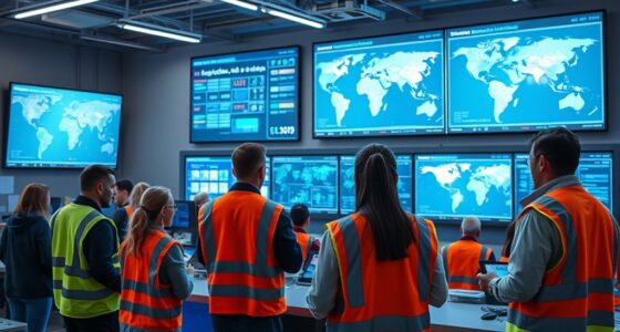
Satellite imagery has become an indispensable tool in emergency response, allowing responders to quickly assess disaster-affected areas from space. When disaster strikes, every second counts, and satellite images provide real-time insights that can save lives and resources. By analyzing high-resolution images, you can identify the extent of damage, locate stranded individuals, and prioritize areas needing urgent assistance. This rapid assessment is essential in coordinating rescue efforts efficiently and effectively. Beyond immediate response, satellite imagery also plays a key role in disaster prediction. By monitoring environmental changes over time, you can detect early warning signs of potential hazards like floods, wildfires, or earthquakes. This proactive approach enables you to alert communities beforehand, reducing risks and preparing populations for upcoming threats. In addition, satellite data enhances urban planning by offering detailed views of city layouts, infrastructure, and land use. With this information, you can design more resilient cities, better equipped to withstand disasters. For example, identifying flood-prone areas or weak infrastructure points allows for targeted improvements that mitigate future damage. Satellite imagery also supports long-term recovery efforts by tracking progress and evaluating the effectiveness of mitigation strategies. As you utilize this technology, you gain an exhaustive understanding of how urban environments evolve and respond to various stresses, informing smarter, safer development. Additionally, the ability to overlay satellite images with demographic and geographic data helps you craft tailored emergency response plans that address specific community vulnerabilities. This integration ensures that resources are directed where they’re needed most, reducing the impact of disasters on vulnerable populations. As satellite technology advances, the resolution and frequency of images improve, giving you more precise and timely information. This continuous stream of data enhances your capacity for disaster prediction, urban planning, and emergency response coordination. By leveraging satellite imagery, you become more equipped to anticipate threats, respond swiftly, and build stronger, more resilient communities. The ability to visualize entire regions from space transforms how you prepare for and manage crises, making rapid, informed decisions possible even in the most challenging situations. Fundamentally, satellite imagery empowers you to take a proactive stance against disasters, combining predictive analytics with urban development strategies to minimize damage and save lives. It’s a game-changer in emergency response, providing the clarity and speed needed to address complex crises with confidence and precision. Additionally, the rising availability of resources and tools makes this technology more accessible and effective for emergency responders worldwide.

Garmin Montana 710i Rugged GPS Handheld Navigator | inReach for SOS & 2-Way Texting, 5” Touchscreen, Satellite Imagery, Topographical Maps for Roads or Trails | Signature Series Power Bundle
BUNDLE INCLUDES: Garmin Montana 710i Rugged GPS Touchscreen Navigator, Signature Series Case, and Signature Series Power Bundle
As an affiliate, we earn on qualifying purchases.
As an affiliate, we earn on qualifying purchases.
Frequently Asked Questions
How Quickly Can Satellite Images Be Deployed After a Disaster?
You can typically access satellite images within hours after a disaster, depending on the provider and the area’s accessibility. Your timeliness assessment considers satellite overpass times, data processing speed, and cloud cover, which can delay imagery. The imagery accuracy remains high, allowing you to evaluate damage and plan response efforts effectively. Prompt deployment ensures you get the vital information needed to make informed decisions quickly.
What Are the Limitations of Satellite Imagery in Emergency Scenarios?
You face limitations like cloud cover, which can obstruct satellite views, delaying clear imagery. Data latency also affects your response time, as it takes time to process and transmit images. Additionally, satellite resolution might not capture small-scale damage, and access can be restricted in certain regions. These factors can hinder quick decision-making during emergencies, requiring you to supplement satellite data with ground reports and other sources for a thorough response.
How Do Satellites Differentiate Between Types of Disaster-Affected Areas?
Think of satellites as detectives with unique spectral signatures, helping you distinguish disaster zones. They analyze different wavelengths to classify terrain and identify affected areas. For example, after a flood, satellite data shows water’s distinct spectral signature, setting it apart from mud or buildings. This terrain classification enables responders to target rescue efforts accurately, ensuring aid reaches the most impacted zones swiftly.
What Resolution Levels Are Typically Used for Emergency Mapping?
For emergency mapping, you typically use high-resolution satellite imagery, often between 0.3 to 1 meter, to detail urban monitoring and assess infrastructure damage. Medium resolutions, around 3 to 10 meters, help analyze vegetation changes and flood extents. The choice depends on the disaster’s scope, but higher resolutions provide more precise data for rapid response, enabling you to identify affected areas quickly and plan effective relief efforts.
How Is Satellite Data Integrated With On-The-Ground Rescue Efforts?
You integrate satellite data into rescue efforts by first ensuring proper satellite calibration for accurate imagery. Then, you transmit real-time data from satellites to ground teams, who use this information for situational awareness. You combine satellite imagery with on-the-ground reports to identify affected areas quickly, plan rescue routes, and allocate resources efficiently. This seamless data flow enhances response speed and accuracy, ultimately saving more lives during emergencies.

Satellite Remote Sensing for Archaeology
As an affiliate, we earn on qualifying purchases.
As an affiliate, we earn on qualifying purchases.
Conclusion
In the fast-paced world of emergency response, satellite imagery acts like your digital Bat-Signal, providing real-time insights that save lives. As you navigate crises, remember that even in a world where smartphones rule, satellite data remains your secret weapon—like having a crystal ball in your pocket. Embrace this technology, for it empowers you to act swiftly and accurately, ensuring you’re always one step ahead, even if your emergency plan isn’t a hoverboard ride!

An Introduction to Applying Satellite Remote Sensing to Disaster Management
As an affiliate, we earn on qualifying purchases.
As an affiliate, we earn on qualifying purchases.
LAND-USE INFORMATION FROM THE SATELLITE IMAGERY: Versatility and Contents for Local Physical Planning
As an affiliate, we earn on qualifying purchases.
As an affiliate, we earn on qualifying purchases.