Digital twins help you simulate future disasters by creating real-time virtual models of your community. They combine data from maps, weather, social media, and infrastructure to provide accurate, up-to-date scenarios. This allows you to test response plans, identify vulnerabilities, and improve coordination among stakeholders. With continuous updates and powerful visualizations, digital twins enable you to make informed decisions before emergencies happen. Keep exploring to discover how these tools can boost your community’s resilience.
Key Takeaways
- Digital twins simulate various disaster scenarios to identify vulnerabilities and improve community resilience.
- Integrating real-time data ensures models reflect current conditions for accurate future disaster planning.
- Continuous updates enable proactive decision-making and testing of response strategies before emergencies occur.
- Shared visualizations enhance stakeholder coordination and resource allocation during disaster responses.
- High-quality visual and data integration support evidence-based strategies, increasing overall community preparedness.

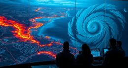
Have you ever wondered how communities can better prepare for natural disasters and emergencies? One promising approach is the use of digital twins—virtual models that replicate real-world environments and systems. These digital counterparts enable you to simulate various disaster scenarios, test response strategies, and identify vulnerabilities before a crisis occurs. When it comes to building urban resilience, digital twins are a game-changer. They allow you to understand how different factors—such as infrastructure, population density, and environmental conditions—interact during extreme events. By creating accurate, dynamic models of your community, you gain insight into potential failure points and areas that need reinforcement, ultimately strengthening your ability to withstand disasters.
Digital twins help communities simulate disasters, identify vulnerabilities, and strengthen resilience before emergencies happen.
A key element in developing effective digital twins is data integration. You need to gather information from multiple sources—geospatial data, weather forecasts, infrastructure maps, social media, and emergency response records—and combine them into a cohesive, real-time system. This integration ensures your digital twin reflects the current state of your community, making simulations more precise and actionable. For example, integrating data about traffic flow and utility networks can help you predict how a flood might disrupt transportation and services, guiding you to deploy resources more efficiently. The more comprehensive and up-to-date your data, the more accurate your models become, allowing you to anticipate challenges and plan accordingly.
Implementing these digital models also means establishing a continuous feedback loop. As new data comes in—such as updated weather alerts or real-time sensor information—you can modify your digital twin to reflect the latest conditions. This ongoing process enhances your community’s urban resilience by enabling proactive decision-making rather than reactive responses. It allows emergency managers, city planners, and first responders to test different scenarios, evaluate potential impacts, and prioritize actions that minimize harm and expedite recovery.
Moreover, digital twins facilitate better communication and coordination among stakeholders. When everyone has access to a shared, realistic simulation, it’s easier to develop unified response plans and allocate resources effectively. This collective understanding boosts community preparedness, ensures faster mobilization during crises, and reduces confusion when disaster strikes. Ultimately, leveraging digital twins with robust data integration transforms disaster planning from guesswork into strategic, evidence-based action, making your community more resilient and better prepared for whatever nature throws your way. Additionally, high-quality visualizations and accurate color representation within the digital twin can improve stakeholders’ understanding of potential impacts, leading to more informed decisions.
Frequently Asked Questions
How Do Digital Twins Adapt to Evolving Community Infrastructure?
You can see digital twins adapt to evolving community infrastructure through dynamic infrastructure updates, ensuring models stay current. They use adaptive modeling techniques to automatically incorporate changes like new buildings, road layouts, or utilities. This way, your digital twin remains an accurate reflection of real-world conditions, allowing you to better anticipate future disasters and plan accordingly. Continuous data integration and real-time monitoring make this process seamless and highly effective.
What Are the Privacy Concerns With Community Data in Digital Twins?
You might worry about privacy concerns with community data in digital twins, especially around data security and consent management. If sensitive info falls into the wrong hands or is used without permission, trust diminishes. Vigilant consent management guarantees residents’ rights are protected, but lapses can lead to breaches. The stakes are high—balancing innovation with privacy demands careful oversight to prevent misuse and maintain community confidence.
How Cost-Effective Are Digital Twin Implementations for Small Communities?
Digital twin implementations can be cost-effective for small communities if you do a thorough cost analysis upfront. Focus on affordable technology options and scalable solutions that fit your budget. Seek funding strategies like grants or public-private partnerships to cover initial costs. By carefully planning and leveraging available resources, you can implement digital twins without overspending, ultimately improving disaster preparedness and community resilience efficiently.
Can Digital Twins Predict Long-Term Impacts of Climate Change?
Yes, digital twins can predict long-term impacts of climate change through advanced climate modeling and predictive analytics. You can simulate future scenarios, analyze potential environmental changes, and assess community vulnerabilities. By continuously updating data, digital twins help you make informed decisions, strengthen resilience, and plan effective adaptation strategies. This proactive approach enables you to better understand and prepare for the evolving challenges posed by climate change over time.
What Skills Are Needed to Develop and Maintain Community Digital Twins?
To develop and maintain community digital twins, you need strong skills in data modeling to accurately represent complex systems, along with cross-disciplinary collaboration to integrate expertise from urban planning, engineering, and data science. You should be adept at using advanced software tools, interpreting data insights, and communicating effectively across teams. Staying updated on new technologies and fostering teamwork guarantees your digital twin remains reliable and useful for community preparedness efforts.
Conclusion
By embracing digital twins, you hold a powerful mirror reflecting your community’s future. This technology becomes a vigilant guardian, alerting you to hidden dangers before they strike, like a lighthouse guiding ships through stormy seas. With every simulation, you’re building a fortress of resilience, turning chaos into clarity. Together, you can transform uncertainty into preparedness, ensuring that when disaster hits, your community stands strong—united, ready, and resilient against whatever storms may come.