
The 1980 eruption of Mount St. Helens changed how volcanoes are monitored and managed. Before the eruption, scientists used seismographs, gas sensors, and early warning systems to track signs of activity. This event spurred the development of advanced monitoring tools like satellite imagery and ground deformation measurements. These improvements help predict eruptions more accurately, saving lives and minimizing damage. If you look further, you’ll discover how these advancements continue to evolve today.
Key Takeaways
- Monitoring technologies like seismographs and gas sensors provided early warnings before the 1980 eruption.
- Post-eruption, advanced networks of sensors improved volcanic recovery tracking worldwide.
- Satellite imagery and ground deformation measurements now enhance understanding of volcanic activity.
- Continuous monitoring helps predict eruptions and guides evacuation and hazard mitigation efforts.
- The 1980 event spurred innovations in volcanic monitoring, boosting early detection and safety strategies.

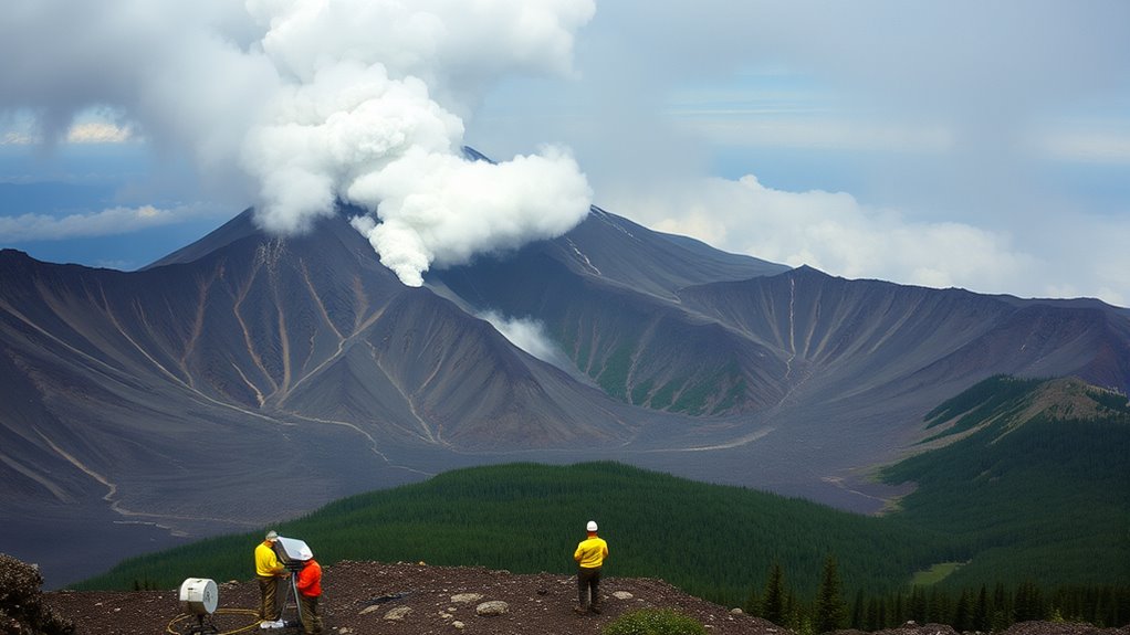
On May 18, 1980, Mount St. Helens erupted with a force that changed the landscape instantly, reminding you of the destructive power of volcano hazards. The eruption was a wake-up call for scientists and residents alike, highlighting the need for effective monitoring advancements to predict such events. You might wonder how experts managed to understand and respond to this catastrophic event. It’s because, over the years leading up to the eruption, significant progress was made in volcanic monitoring technology, allowing scientists to detect signs of unrest and issue warnings more accurately.
Before the eruption, the volcano exhibited signs of activity—rumblings, small earthquakes, and increased gas emissions—that hinted at an impending eruption. Thanks to monitoring advancements, seismographs and gas sensors provided crucial real-time data, giving scientists a clearer picture of what was happening beneath the mountain. These tools allowed them to observe subtle changes in magma movement and pressure buildup, which are key indicators of potential eruptions. Without this technological progress, the eruption might have caught authorities off guard, leading to even greater loss of life and property.
Your awareness of volcano hazards has grown because of these monitoring efforts. Today, volcanic monitoring isn’t just about watching seismic activity; it also involves satellite imagery, ground deformation measurements, and even thermal cameras. These tools help scientists track the volcano’s behavior long before an eruption occurs. In the case of Mount St. Helens, continuous monitoring helped scientists understand the evolving nature of the volcano’s activity, enabling them to issue timely evacuations and warnings. This technological evolution has saved lives and minimized damage, transforming volcanic risk management from reactive to proactive.
The 1980 eruption also spurred further advancements in monitoring systems, leading to the development of networks of sensors around active volcanoes worldwide. You learn about the importance of early detection, which hinges heavily on these advancements. Modern volcano monitoring combines multiple data sources, giving a *essential* view of the volcano’s state. This integrated approach allows you to stay informed about potential hazards and take appropriate safety measures.
Ultimately, the Mount St. Helens eruption underscored how *indispensable* monitoring advancements are in managing volcano hazards. They provide the *crucial* information needed to understand volcanic behavior, predict eruptions, and protect communities. As you look to the future, ongoing improvements in monitoring technology will continue to enhance our ability to anticipate and respond to volcanic threats, ensuring that we’re better prepared for the next chapter in Earth’s volcanic activity.
Frequently Asked Questions
What New Species Have Been Discovered Around Mount St. Helens?
You’ll find a remarkable biodiversity resurgence around Mount St. Helens, including the discovery of new microbial species. Scientists have identified unique microbes thriving in the volcanic soil, showcasing how life adapts in extreme environments. These findings highlight the area’s ongoing ecological recovery and add to our understanding of microbial resilience. Your exploration of this region reveals a vibrant, evolving ecosystem, with new species continually emerging amid the volcanic landscape.
How Do Scientists Predict Future Eruptions at Mount St. Helens?
You can’t predict eruptions at Mount St. Helens with absolute certainty, but scientists get pretty close by using seismic monitoring and eruption forecasting. They watch for tremors, ground deformation, and gas emissions that signal an impending eruption. It’s like having a volcanic weather forecast, giving you vital warning signs. While no method is perfect, combining these techniques helps keep people safe and provides a clearer picture of what’s coming next.
What Impact Did the Eruption Have on Local Indigenous Communities?
You see that the eruption profoundly impacted indigenous communities by threatening their indigenous cultural heritage and disrupting traditional land use. Their sacred sites, hunting grounds, and fishing areas were damaged or inaccessible, forcing them to adapt and relocate practices. This event underscores the importance of respecting indigenous connections to the land, recognizing their ongoing cultural significance, and involving them in recovery efforts to preserve their traditions and heritage.
How Has Tourism Changed Since the 1980 Eruption?
Think of Mount St. Helens as a reborn phoenix, inspiring a new era of volcano tourism. Since 1980, visitor infrastructure has expanded, offering guided tours, interpretive centers, and safe vantage points. More travelers now come to witness the awe-inspiring landscape, fueling local economies. This growth reflects a deeper appreciation for volcanoes, transforming the mountain from a symbol of destruction into a beacon of resilience and natural wonder.
Are There Any Ongoing Geothermal Energy Projects Near Mount St. Helens?
Currently, there are no active geothermal development or energy projects near Mount St. Helens. You won’t find any ongoing geothermal energy projects because the area is primarily protected for its ecological and volcanic significance. While geothermal energy is a promising renewable resource in other parts of the Pacific Northwest, the region around Mount St. Helens remains focused on conservation and monitoring, rather than development of energy projects.
Conclusion
As you observe Mount St. Helens, you see a volcano reborn, like a phoenix rising from the ashes. The ongoing recovery and monitoring efforts show how resilient our planet can be, even after destruction. By studying this volcano, you gain insight into nature’s power and its ability to heal itself over time. Stay curious and watchful, because just like the mountain, our understanding continues to grow, shaping a future where we coexist with Earth’s dynamic forces.